About the product
DIGITAL SURVEY & DESIGN CONSULTANT
We do Digital Survey & Design: We expose your prestige impression
Contact Information: Engr. Md. Akter Hossain (Chief Executive Officer)
Cell: 01718307750 Imo:+ whatsApp: 01718307750 Viber: 01916266825
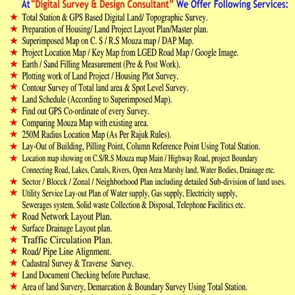
Our Services: We bring innovative solutions by approaching project from different angles like.
Digital Land Survey (ডিজিটাল ল্যান্ড সার্ভে)/Topographical Survey (টপোগ্রাফিক সার্ভে) & Mapping.
Preparation of Housing/Land Project Layout Plan/Master plan.
Superimposed Map on C.S/R.S/B.S Mouza map/DAP Map.
Project Location/Key map from LGED Road map/Google image.
Earth/Sand Filling Measurement (Pre & Post work) & Volume calculation.
Plotting work of Housing/Land Project/Plot survey work.
Land Schedule (According to Superimposed map).
Contour Survey (কন্টুর সার্ভে) of Total land area & Spot Level survey.
Find out G.P.S Co-ordinate of every survey.
Comparing Mouza Map with Existing Area.
250M Radius Location Map (As Per Rajuk Rules).
Area of Land survey, Demarcation & Boundary Survey using Total Station.
Industrial Area Survey showing all Present Topographical object as like.
Building Plan, Design, Estimate, Construction Layout (ডিজিটাল লে-আউট) & Supervision etc.
Office: House#180 (1st Floor), Road#4, Block# F, Section# 11, Journalist R/A, Mirpur, Dhaka-1216
Ph:+88 01916-266825, 01718-307750, E-mail: [email protected], [email protected]
www.digitallandsurveybd.com, Linkedin.com/in/Engr-Md-Aktar-Hossain-5203437a, Facebook: Digital Survey BD
We do Digital Survey & Design: We expose your prestige impression
Contact Information: Engr. Md. Akter Hossain (Chief Executive Officer)
Cell: 01718307750 Imo:+ whatsApp: 01718307750 Viber: 01916266825
Our Services: We bring innovative solutions by approaching project from different angles like.
Digital Land Survey (ডিজিটাল ল্যান্ড সার্ভে)/Topographical Survey (টপোগ্রাফিক সার্ভে) & Mapping.
Preparation of Housing/Land Project Layout Plan/Master plan.
Superimposed Map on C.S/R.S/B.S Mouza map/DAP Map.
Project Location/Key map from LGED Road map/Google image.
Earth/Sand Filling Measurement (Pre & Post work) & Volume calculation.
Plotting work of Housing/Land Project/Plot survey work.
Land Schedule (According to Superimposed map).
Contour Survey (কন্টুর সার্ভে) of Total land area & Spot Level survey.
Find out G.P.S Co-ordinate of every survey.
Comparing Mouza Map with Existing Area.
250M Radius Location Map (As Per Rajuk Rules).
Area of Land survey, Demarcation & Boundary Survey using Total Station.
Industrial Area Survey showing all Present Topographical object as like.
Building Plan, Design, Estimate, Construction Layout (ডিজিটাল লে-আউট) & Supervision etc.
Office: House#180 (1st Floor), Road#4, Block# F, Section# 11, Journalist R/A, Mirpur, Dhaka-1216
Ph:+88 01916-266825, 01718-307750, E-mail: [email protected], [email protected]
www.digitallandsurveybd.com, Linkedin.com/in/Engr-Md-Aktar-Hossain-5203437a, Facebook: Digital Survey BD
Price
1.000
Contact with supplier